 |
|
|
「2002 太平洋鄰里協會年會暨聯合會議」, 日本大阪市立大學 2002年3月28日 Digital Media, Informatics, and Cultural Heritage |
| Page 10 of 13 |
|
|
= A System of Chinese Civilization in Time and Space (CCTS, http://gis.ascc.net/ccts/)This
is a part of the works conducted by the Institute of History and Phonology
in cooperates with the Computing Center of Academia Sinica. The project
directors are Dr. I-Chun Fan and Mr. Eric Yen. Based
on the requirements of multi-disciplinary research applications, the goal of
this system is constructing an integrated GIS-based application
infrastructure on the spatial extent of China, in the timeframe of Chinese
history, and with the contents of Chinese civilization. Although target
users of this system are primarily set to be scholars, academic experts, and
schoolteachers, most general spatial-and temporal-based applications are
also provided. A feedback mechanism was established for collecting research
and application results continuously to fertilize contents and elaborate the
value of information integration for our users. This
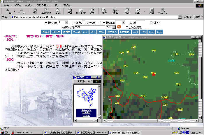
system consists of basic geospatial materials, WebGIS integrated application
environment, and thematic information. The fundamental base maps come from
Dr. Tan's "The Historical Atlas of China", which is composed of 8
volumes with 21 map groups that holds 307 maps, and covers 2000-year long
Chinese historical features from the ancient time to Qing dynasty. All the
maps were georeferenced with accuracy in 2 mm. Administrative boundaries and
inhabited localities had been vectorized, other major themes are partially
digitized based on research requirements. Furthermore, the distribution of
cultural areas in pre-historical stage was incorporated and extends the
temporal coverage to 7,000 BC. Millions of historical atlas and remote
sensing imagery are persistently geo-referenced and overlaid into the system
to broaden the spatial and temporal scope and for various applications.
This
system has the following features: 1.
A WebGIS-based distributed application infrastructure is constructed
to provide both content navigation and Web mapping.
2.
Lower
the cost for doing things in GIS way, and with shorter learning curve.
3.
Capable of integrating any geospatial and attribute information in
the Internet.
4. Users could upload their results and contribute to the system, or just save to their local clients alternatively 5. Having scalability, integration and access control consideration into the design. As
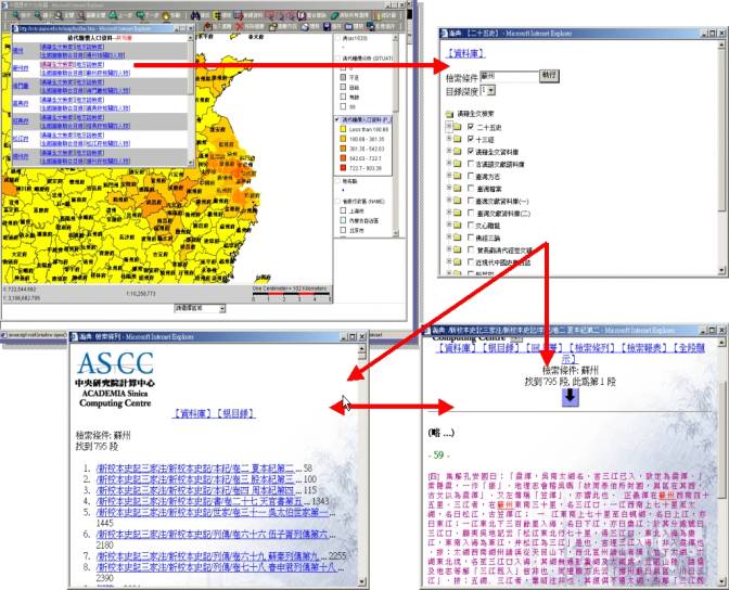
an application example of this system, the systems of Scripta Sinica (漢籍電子文獻系統,
It is a huge collection of digitized ancient Chinese books, over 400M
Chinese characters at present.) and some catalogs of local gazetteers in
Ming
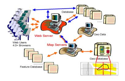
and Qing Dynasties has been integrated into CCTS. A diagram shows the
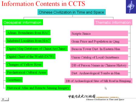
system architecture of CCTS is shown in Figure 5. And, the information
contents of CCTS are in Figure 6.
Figure
5: System Architecture of CCTS |
|
Organization |
Location |
Notes |
|
National
Palace Museum |
www.npm.gov.tw/dl/ |
|
|
National
Library |
readopac.ncl.edu.tw/NDAP |
Academic
periodicals and newspapers database of Taiwan |
|
National
Museum of Natural Sciences |
digimuse.nmns.edu.tw digimedia.nmns.edu.tw |
Including
Zoology, Botany, Geology and Anthropology databases |
|
Taiwan
Provincial Archives |
www.hrctp.gov.tw |
|
|
National
Taiwan Univ. |
libftp.lib.ntu.edu.tw/project/ |
Image
database of the scripts of伊能嘉矩(1867-1925) |
|
Academia
Sinica |
www.sinica.edu.tw |
General |
|
fishdb.sinica.edu.tw |
Fish |
|
|
shell.sinica.edu.tw |
Shellfish |
|
|
gis221.sinica.edu.tw/website/metadata |
GIS |
|
|
ihp.sinica.edu.tw |
General |
|
|
archives.sinica.edu.tw |
History
records |
|
|
| Page 10 of 13 |
|